forecast
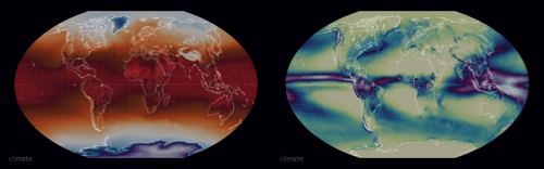
an interactive map of climate forecasts
data and visualisation produced by the climate data factory
based on calibrated sub-seasonal and seasonal forecast
see
Ready-to-use climate forecast
Displayed Data
Four weeks and six months outlooks based on the blending of
four forecasting models from UK, Italy, Germany, and France.
the data represent conditions at near ground or water level
a layer that follows the contours of the sea, valleys, mountains, etc.
Map
| Terciles | Probability of being below or above normal conditions |
| Anomalies | Average departure from normal conditions |
Horizon
| M1 to M6 | Month 1 to Month 6 |
| W1 to W6 | Week 1 to Week 4 |
Variables
| Temperature | Temperature at 2 meter above ground |
| Precipitation | Total precipitation (water and/or snow) at ground surface |
| Warm Days | Number of days above the daily maximum temperature 90th percentile |
| Warm Nights | Number of days above the daily minimum temperature 90th percentile |
Keyboard Shortcuts
| e | show the menu |
| escape | close dialog/menu |
| n | go to now (the most recent data) |
| shift-c | show the date selection calendar |
| u | go backward one time step |
| shift-u | go backward several time steps |
| i | go forward one time step |
| shift-i | go forward several time steps |
| j | go backward one forecast horizon step |
| shift-j | go to the first forecast horizon step |
| k | go forward one forecast horizon step |
| shift-k | go to the last forecast horizon step |
| g | toggle the grid on/off |
| p | toggle the animation on/off |
| shift-t | show settings |
| d | zoom in |
| shift-d | zoom in faster |
| x | zoom out |
| shift-x | zoom out faster |
| w | rotate up |
| shift-w | rotate up faster |
| z | rotate down |
| shift-z | rotate down faster |
| a | rotate left |
| shift-a | rotate left faster |
| s | rotate right |
| shift-s | rotate right faster |
Credits
| Inspired and adapted from | earth.nullschool.net |
| Open version of code | github.com/cambecc/earth |
| Hosting | Amazon S3 |
| CDN |
CloudFlare |
| Color Scales |
ColorBrewer2.org |
terms of service apply
Copyright (c) 2024 the climate data factory